growing with better intention
I love helping people understand the land they’re on. When someone is new to gardening, they may have heard of their “grow zone” – mine is zone 6b – and how much sun the spot where they want to garden gets. Yes, those are both helpful things to be mindful of, whether you’re planting in the ground, in a raised bed, or in containers. But that’s not the whole story.
There’s an important metric, resource, larger piece of information that most people don’t know about, but when you’re looking at the big picture of gardening, it ties together all the smaller bits of information you notice (and possibly even notate) – ecoregions.
What the heck are ecoregions?
A simple definition is ecoregions are areas that have similar climate, geology, and soils.
Here’s the background on how these were developed:
“Ecoregions are areas where ecosystems (and the type, quality, and quantity of environmental resources) are generally similar. This ecoregion framework is derived from Omernik (1987) and from mapping done in collaboration with EPA regional offices, other Federal agencies, state resource management agencies, and neighboring North American countries. Designed to serve as a spatial framework for the research, assessment, and monitoring of ecosystems and ecosystem components, ecoregions denote areas of similarity in the mosaic of biotic, abiotic, terrestrial, and aquatic ecosystem components with humans being considered as part of the biota. These regions are critical for structuring and implementing ecosystem management strategies across Federal agencies, state agencies, and nongovernmental organizations that are responsible for different types of resources within the same geographic areas (Omernik and Griffith 2014, McMahon et al. 2001).
Ecoregions are identified by analyzing the patterns and composition of biotic and abiotic phenomena that affect or reflect differences in ecosystem quality and integrity (Omernik 1987, 1995). These phenomena include geology, landforms, soils, vegetation, climate, land use, wildlife, and hydrology.” [EPA website, accessed April 22, 2026]
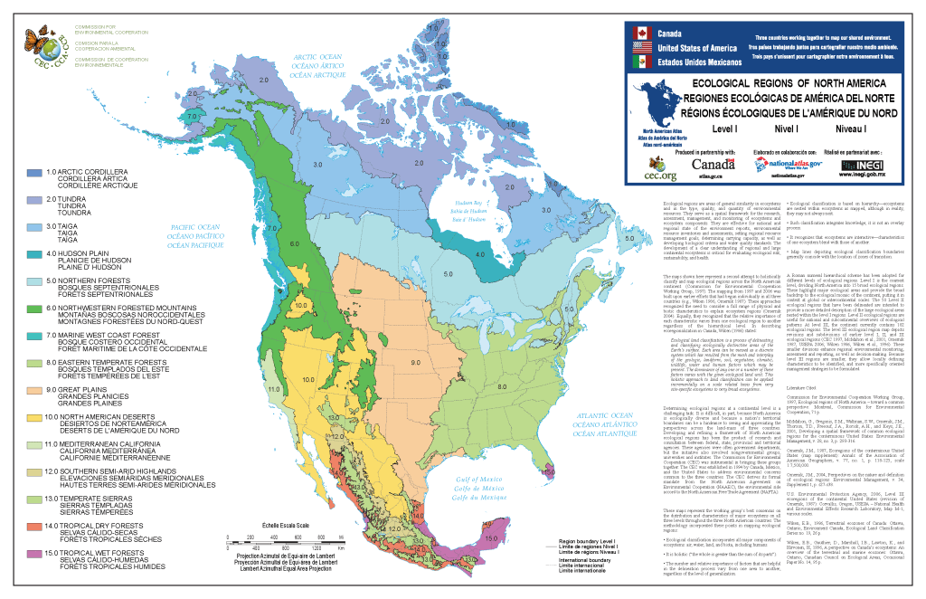
It’s very formal language to say areas are lumped together through similar ways the land looks, what the soil is made up of, the native plants and animals, the relative humidity, and the water. They transcend national borders – think the Great Plains (9.0 beige) and the deserts of North America (10.0 yellow). If you look at the map below, both of them extend from Canada, through the US, and into Mexico. They are very distinct swaths of land in relation to what the soil is made of, the amount of rainfall, what animals and plants thrive there, etc.
Are these really important to know?
Do I really need to know all this when I’m just trying to grow some tomatoes and some petunias every summer?
Heck yeah!
Just like you don’t want to plants dahlias tubers outside before any chance of frost happens (FYI – if tubers in the ground freeze and then thaw, there’s a good chance they’ll rot too, and then no spectacular blooms come summer), planting flowers outside of its native ecoregion can have all kinds of effects…
- there might not be enough rain or humidity for it to thrive
- your ecoregion may be such an ideal growing condition for a plant that it spreads everywhere – this is what’s called “invasive” and can have devastating consequences on the native plant, insect, and animal life in your area.
- the soil may be too acidic or alkaline for the plant you want. This can be remedied with different soil amendments, but you also run the risk of contaminating the water or making the soil inhospitable for other plants.
The USDA Plant Hardiness Zone map is based on the average annual extreme minimum winter temperature, so you know that tropical plants like Caladium (Elephant Ear) won’t survive a harsh winter with snow and ice. The Last Spring/First Fall freeze dates help you plan when to sow seeds directly into the ground, or bring out those seedlings you’ve been growing in a heated greenhouse or inside your home.
Let’s walk this through a concrete example. Take the USDA grow zone 6b. That’s here in my area of New England (Brookline, Massachusetts), but it’s also Topeka, Kansas and Spokane, Washington.
Brookline’s last frost date is April 19 (50% chance of 36℉ is May 2)
Topeka’s is April 12 (50% chance of 36℉ is April 24)
Spokane’s is May 1 (50% chance of 36℉ is May 8)
Those are VERY different, especially if you want to put out non-cold hardy veggies like tomatoes and peppers, or annuals like zinnia, cosmos, and sunflowers.
Now let’s layer in the ecoregions and subregions…
Regions and subregions
I know. Minutiae. But, I promise, also important. And you only have to figure this out once and write it down (and remember where you wrote it down. IYKYK)
I’ll give you the breakdown in North America, and with each level we’ll look at our three examples.
- 15 broad, Level I ecological regions
- Brookline: 8.0 EASTERN TEMPERATE FORESTS
- Topeka: 9.0 GREAT PLAINS
- Spokane: 6.0 NORTHWESTERN FORESTED MOUNTAINS (and close to 10.0 NORTH AMERICAN DESERTS)
- 50 Level II ecological regions intended to provide a more detailed description of the large ecological areas within the level I regions
- Brookline: 8.1 MIXED WOOD PLAINS
- Topeka: 9.2 TEMPERATE PRAIRIES
- Spokane: 6.2 WESTERN CORDILLERA
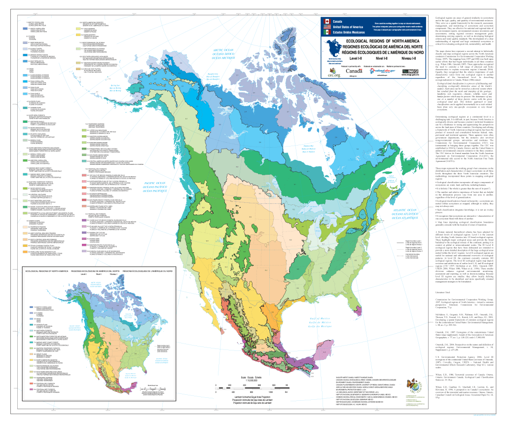
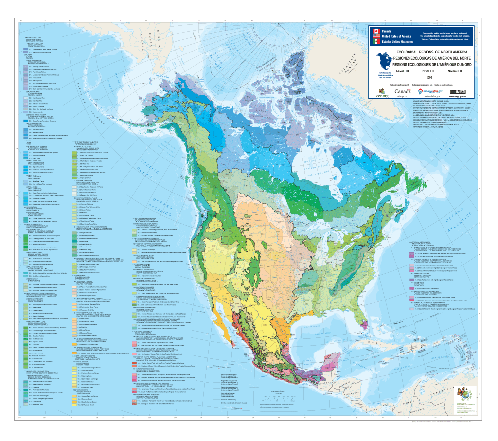
- 182 Level III ecoregions, which are areas nested within level II regions
- Brookline: 8.1.7 Northeastern Coastal Zone
- Topeka: 9.2.4 Central Irregular Plains
- Spokane: 6.2.3 Columbia Mountains/Northern Rockies
See how it builds up from level to level? Now to drill down into what that means when you want to create a garden.
what can I grow in my ecoregion?
I would not be recommending the same plants for those three very distinct areas, but if we’re layering the information of the ecoregion levels, we get a way better picture of what to grow and when.
A synopsis of my area (8.1.7) includes “nutrient-poor, rocky soils, and an abundance of glacial lakes. The terrain consists of irregular plains, sometimes interspersed with tall hills. The underlying bedrock is diverse, mostly a mixture of igneous and metamorphic rocks, with some areas of sedimentary rock. The climate is a humid continental climate with warm summers and rather severe winters; precipitation is roughly equally distributed year-round. Originally, this region was covered by Appalachian oak forests and northeastern oak-pine forests. Dominant trees include white oak, northern red oak, hickories, eastern white pine, with maple, beech, birch, and hemlock in cooler areas.
“Historically, this region was farmed more than today, although the nutrient-poor soil often yielded poor results, leading agriculture to be abandoned more quickly here than in more fertile regions to the southwest. Some farms remain, but the majority of the region is taken up by a mix of woodlands and urban and suburban development.
“Surface waters in this area, including both lakes and streams, are sensitive to acidification caused by acid rain.” [https://bplant.org/region/116, accessed April 22, 2026]
So, I can plant maple trees (except Norway maples – they’re invasive to this area). Or Lupinus perennis (sundial lupine) and Solidago puberula (downy goldenrod) to help feed the native pollinators, and Asclepias tuberosa (butterfly milkweed) if I have a lot of deer and rabbits. I personally do a mix of natives and more traditional flowers for my garden.
Do I expect beginners to figure all this out and plan accordingly right away? Not at all. Figure out how to successfully plant from seed. Try growing in containers, or raised beds, or right into the earth. Take some notes each year, so you remember what went well and what went wrong from year to year.
What I’ve given you here is next level information, but knowing and implementing it can not only help you be more successful, but also feed the ground beneath your feet.
resources:
https://planthardiness.ars.usda.gov/ – type in your zip code to find your plant hardiness zone
https://www.climate.gov/news-features/understanding-climate/interactive-map-average-date-last-spring-freeze-across-united – interactive map to find the last spring freeze date in your area
https://www.cec.org/files/documents/publications/10415-north-american-terrestrial-ecoregionslevel-iii-en.pdf – descriptions of every Level III ecoregion in North America
https://www.epa.gov/eco-research/ecoregions-north-america – the EPA’s website about ecoregions

Leave a comment